Brenner Base Tunnel: Project status
Unfortunately the construction schedule is not available.
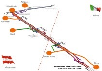
The 64 km long Brenner Base Tunnel (BBT) is a flat trajectory railway tunnel between Innsbruck/A and Franzenfeste/I. It is part of the European TEN 1 axis, which foresees the construction on a rail corridor linking countries together. The BBT comprises 2 parallel main bores as well as the exploratory bore located beneath them. In March 2011, 16 km of exploratory tunnel and access tunnel had been completed. The following report deals with the stage reached by the construction activities.
1 Basic concept
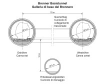
The Brenner Base Tunnel is a nearly horizontal rail tunnel with 2 parallel tubes. The tunnel runs for 55 km between the railway stations of Innsbruck and Fortezza and is connected south of Innsbruck with the already existing underground by-pass. This bypass and the Base Tunnel make up the world‘s longest underground railway, with a total length of about 64 km.
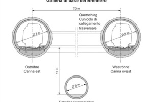
An exploratory tunnel runs between and 12 m deeper than the 2 tubes of the rail tunnel.This will be built in sections before the construction of the main tubes, primarily to explore the rock mass. This exploratory tunnel will be completed to run end-to-end in the final phase of construction, so that it may be utilized as a drainage tunnel and, if necessary, as a service tunnel [1].
The main characteristics of the Brenner Base Tunnel are (Figure 2):
- Length: 64 km
- Longitudinal gradient: 5.0 ‰ to 6.7 ‰
- Crown height of the Base Tunnel: 795 m above sea level
- Net cross-section of the main tubes: about 43 m2
- Minimum cross-section of the exploratory tunnel about 26 m2
- Clearance of the cross-cuts: 300 m.
2 Current planning status
2.1 Current state of the authorization procedures
The technical project was authorized and the environmental compatibility confirmed by the governments of Austria (April 15th 2009 authorization according to the Austrian law on railways and EIA approval) and Italy (July 31th 2009 CIPE decision) in 2009. By the end of 2010 preparatory work was undertaken and approx. 15 km of the exploratory tunnel and the access tunnel had been built. In phase I, from 1999 to 2002, the preliminary project was developed. Between 2003 and 2008, in phase II, more than 26.000 m of prospection borings, the technical final project and the planning for environmental compatibility were completed.
On November 18th, 2010 further financing and the start of phase III (building phase) in Italy were approved by CIPE. On February 1st,2011 Austria´s federal Cabinet approved further financing of preparatory construction works and in-depth prospection. The start of construction work in the main construction lots is scheduled for 2016 and the completion of the Brenner Base Tunnel for 2025.
2.2 Cross-project system planning (guide design)
In February 2011, the cross-project system planning was tendered Europe-wide, to create a solid, uniform basis for subsequent planning. The essential elements of this integrated planning are:
- Revision of the route planning incorporating all optimizations
- Regulatory principles and technical specifications for the lot-based tendering and executive planning
- Principles for the design and construction detailing for a service lifetime of 200 years
-Creation of detailed interface and type plans
- Tolerances (surveying and construction method-dependent tolerances), taking into account the subsequent works
- Measures for development of the railway infrastructure.
In addition, the entire UTM-based route planning was placed in a project-specific coordinate system: BBT-TM, produced by a transverse Mercator projection. Thus, the average orthometric height of 720 m for the project was determined, which is about a 770 m ellipsoidal height. The project lies therefore in an area about 10 km east and west of the central meridian. The distance distortion in this case is less than 2 to 3 mm/km.
Thus, for this reference system, no further rotation must be performed, as the meridian convergence is easy to calculate and the resulting reduction effect on the directions is insignificant (the convergence angle is about 4‘).
2.3 Geo-referenced data and WebGis
The entire planning of the Brenner Base Tunnel was based on geo-referenced data. The project was developed with UTM -WGS84 coordinates, using the international agreement for the projection of the WGS84 ellipsoidal geographic coordinates according to Gauss. Calculation was done by means of a transverse cylindrical projection, applying a scale factor of 0.9996 for strip 32; using this approach the central meridian is at 9° longitude, with an E-coordinate of 500 km, while the N-coordinates originate at the equator.
The project area is located 2°40‘ east of the central meridian of the strip; so, the meridian convergence, or the difference between geographical and grid north, is considerable. Therefore, it is advantageous to transform the project data into a flat reference system that is better adapted to route planning operations. The differences between the project data and the line routing are therefore minimal and marginally insignificant:
UTM-WGS84 system
- East = 692294.890
- North = 5206131.024
- H (UELN) = 804.942
- Long. = 11° 31’ 42.5775”
- Lat. = 46° 58’ 50.7947”
The point of contact of the cylinder to the ellipsoid is the focus of the project, which is the high point of the project axis (East-tube - Tr.1) and lies near the border between Italy and Austria. The following data are used for the geographical definition:
Ellipsoid WGS84
- Central meridian of the strip = 11° 31‘ 42.5775“
- Function coordinate
- East = y0 = 20000,000 m
- Function coordinate
- North = x0 = -5105739.717 m
- Scale factor = 1.000121
The advantage of this approach is that a single system can be used for the entire construction project, without the problems arising that are ordinarily incurred when different systems are used for each tunnel sections.
The new reference system, which is produced by a transverse Mercator projection, is called BBT_TM-WGS84 and will have the following coordinates: x (North), y (East).
3 Construction schedule
The 2010 Brenner Base Tunnel construction program was prepared on the basis of many improvements according to EIA approvals. The construction program was set forth in the form of a time-phased workload chart following a detailed analysis. It was necessary to take into account, besides the various tunnelling methods, the planning and tendering and procurement times. Additionally, international experience from already constructed tunnels was included. The time-phased workload diagram covers the entire range of construction activities from the structural work through to the start of operations and the necessary planning services without considering the yet unknown project risks.
The program provides for the construction work to be divided into 5 main lots:
- 2 construction lots for the exploratory tunnel and part of the main tunnel and
- 3 main construction lots.
About 1/3 of the exploratory tunnel is to be excavated with conventional and 2/3 with mechanical tunnelling methods. The access tunnels will be excavated exclusively by conventional means. About 1/4 of the construction of the main building lots will take place with conventional and about 3/4 with mechanical excavation methods. The tunnels connecting with the Innsbruck by-pass are to be excavated conventionally.
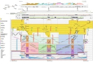
The 2010 Brenner Base Tunnel building program was prepared according to EIA approvals, new improvements in construction logistics and improved geological and hydrological knowledge. This construction program (known to the media as the Bergmeister Plan) was approved by the BBT SE Supervisory Board and is the basis for further investments and works (Figure 3).
4 Projected total costs
The costs of the Brenner Base Tunnel have been largely determined using the item method on the basis of the 2008 final project. In addition, the costs of compulsory EIA measures and external evaluation were considered. The estimated total costs from 1 July 2006 to 1 January 2010 were also value-adjusted (Table 1).
Based on a risk analysis, the risks considered were those identified as having a medium and high probability of occurrence. In order to take account of those risks which may be expected but are currently not yet identifiable and quantifiable, the ÖBB (2007) manual to determine costs and the Austrian ÖGG directive „Cost analysis for transport infrastructure projects“ (2005) were used to estimate the necessary risk provisions on the basis of many years of experience in infrastructure projects [3].
This additional quota is calculated as 602 mio. Euro. Based on the Austrian ÖGG directive, total risk provision is 1,144 mio. Euro (risk provision for theoretical risks with a medium-high probability f occurrence and the expectable, but still not identifiable and quantifiable risks). With this risk provision the projected total costs of the Brenner Base Tunnel on 1 January 2010 is 8,062 mio. Euro.
5 Geological evidence from the exploratory tunnel
Construction of the exploratory tunnels is primarily for preliminary exploration [4]. In the Innsbruck - Ahrental exploratory tunnel, geological documentation by internal BBT personnel will be carried out to improve knowledge and experience for further planning. In geologically difficult sections (fault areas) each advance will be documented, in uniform conditions or sections with the same geology, every second advance. In the geological mapping of the rock face, the bedrock face type, the rock physical parameters such as hardness and weathering, the formation and spatial position of the relevant joints and the mountain water conditions will be observed, measured and recorded. The data collected will be managed through the tunnel database software „2-DOC“ and corresponding advancement reports created. Continuous tracking of geological sections will be set up, in which the extended geology is summarized. Similarly, at regular intervals, a report to the competent authorities will be issued.
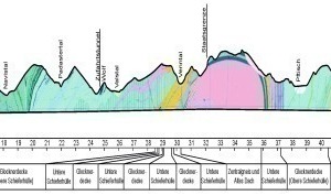
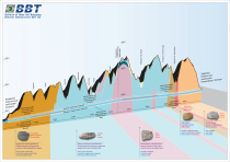
Valuable insights from both the exploratory tunnel sections through the Innsbruck quartz phyllite and Brixner Granite have already been obtained (Figure 4).
5.1 Innsbruck quartz phyllite
The 2 Innsbruck-Ahrental exploratory tunnels and Ahrental access tunnel of the Innsbruck - Ahrental exploratory lot lie entirely embedded in Innsbruck quartz phyllite. Roughly the first 14 km of the BBT tunnel system starting from the Innsbruck portal are to be cut through the Innsbruck quartz phyllite zone. It ranges from Innsbruck, bounded on the west by the Wipptal, until the Navistal where it is displaced or separated by a major fault zone with rocks of the Tauern window.
„Quartz phyllite“ is a stratification of different phyllites with quartzite and gneiss layers. It is a rock that breaks up easily into slates and thin layers and mainly consists of layered silicates (mica) and quartz. The schistosity as the main joint face is flat. Quartz phyllite is a dense rock due to its high proportion of mica and has led to predictions of very low water inflows into the tunnel. The small-scale marbles and dolomitic marble bodies embedded within it can be enriched with mountain water. If they are „tapped“ during tunnelling, the water from within will dry up within a few days. This is aptly described as „bleeding“.
5.1.1 Innsbruck - Ahrental exploratory tunnel
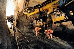
The excavated cross-section of this tunnel is about 26 m2. In this section, individual advancements up to 2.20 m were possible. Due to technical preparation of the surface geology, several weakness or fracture zones and so-called fault areas were predicted for the exploratory tunnel. Along these fault areas, the rock was broken up and pulverized by orogenic processes. More such fault lines were foreseen especially for the crossing under Lake Lans, on account of surface mapping and analysis of aerial photographs. It was therefore feared that the cutting into these faults while tunnelling could threaten the water balance of Lake Lans.But in fact, unfractured rock masses were found when tunnelling the underpass in the area of Lake Lans.The total of the accumulated mountain water so far is only about 0.1 l/s and is significantly less than the already low mountain water levels that had been predicted. So far no larger faults have been encountered, the rock mass shows only partial tectonic stress in the form of shear bands a few centimetres thick , along which the quartz phyllite is ground to a clay-like powder. A major fault is predicted around the 2,400 m point in the tunnel excavation, the so-called Ahrental fault. The tunnel is to break through the fault at a right angle or, by the shortest route. In general, faults in quartz phyllite are found at a certain depth - from a depth of 50 m – and they are dense and not water-bearing. Starting from a certain covering, they can rather pose a risk of slow and steady pressure from the rock mass, what tunnel builders refer to as „squeezing“ behaviour (Figure 5).
5.1.2 Ahrental lateral access tunnel
The excavated cross-section is about 90 m2; excavation in this section is cyclical, which means that first the tunnel cap, then the side wall and the base slab, are tunnelled out.
Due to the proximity of the Ahrental lateral access tunnel to the Wipptal fault which separates the rocks of the Ötztal and Stubai Alps from the large quartz phyllite mass, the rock mass in this tunnel is visibly fractured, from its beginning onwards. Up to about the first 30 m of the tunnel, glacial gravel deposits were found in the upper part of the tunnel cross-section. Loose rock and the cutting of the underpass beneath the motorway required a pipe roof (2 x 18 m).
There were also repeatedly occurring traces of marble in the quartz phyllite, most of them water-bearing, but which quickly „bled out“. The complications during tunnelling are the joints that dip steeply to the west in the direction of the Wipptal. Therefore, only short advancements of up to at most 1.3 m were possible during tunnelling. Due to the regional geological situation, the ground conditions should however improve gradually as the distance from the Wipptal fault increases.
5.2 Brixner Granite
The tectonic unit of the Permian age Brixner Granite consists of granite, and minor aplite and pegmatitic courses. It is not metamorphic, but was stressed by Alpine mountain building tectonics. This complex is characterized by brittle faults.
Brixner granite is a leucocratic medium-grained rock with an isotropic texture. The results of 40 thin-section analyses reveal the mineral composition of the rock to be 30 to 40 % quartz, 20 to 30 % orthoclase, 20 to 30 % plagioclase and 10 to 15 % biotite. Secondary minerals are white mica, chlorite, albite, titanite, epidote, calcite and opaque minerals. The rock often contains micro-fissures about 20 μm in thickness, which may be filled with calcite, albite, white mica and quartz.
5.2.1 Aica - Mules exploratory tunnel
The Aica - Mules exploratory tunnel, which is over 10 km long, lies entirely in Brixner Granite. The geological prognosis estimated 18 faults in the Aica exploratory tunnel with a length of 10.4 km. 8 faults were encountered here.Around 2,560 m an unpredicted fault was encountered which caused slight deformation and cracking in the concrete segments. The thickest fault is the Weissenbach fault, which was predicted at 5,830 m into the tunnel with a thickness of 50 m. It was found before that, between 5,760 and 5,864 m into the tunnel and was accompanied by frequent water inflows. At 6,151 m into the tunnel, an approx. 5 m thick fault running parallel to the tunnel, which had not been predicted, was encountered.This rather unimportant geological fault, due to its parallel orientation to the tunnel axis, caused intense deformations of up to 60 cm of the tubbing rings. This caused a nearly 4-month shutdown of the TBM.
The prognosis for the Aica exploratory tunnel was 150 l/s (stabilized) and 290 l/s (maximum). In fact, the trend shows a stabilized capacity of 70 l/s. Maximum capacities were approx. 200 l/s.
The forecasts for the total water discharge from the Aica – Mules access tunnel were 25 l/s (stabilized capacity) and 230 l/s (maximum capacity). In fact, the stabilized capacity was about 6 l/s and the maximum capacity was about 10 l/s (Figure 6).
A rock density of 2.67 kN/m3 was determined from 180 samples taken from the Aica exploratory tunnel. The uniaxial compressive strength amounts to 142 MPa (standard deviation 33 MPa). The prognosis was given as a mean uniaxial compressive strength of 133 MPa. The average Cerchar abrasiveness was 3.87 (standard deviation 0.67).
The Brixner Granite shows stable rock behaviour. In some cases it showed phenomena similar to rock bursts. In the „damage zone” area of the faults, the face was unstable. This was caused by additional unfavourable fracture systems. In the „core zone“ area of the faults sporadic deep overstressing of the rock occurred (fault at 6,151 tunnel meters).
6 European Dimension and Perspectives
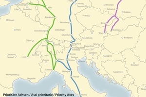
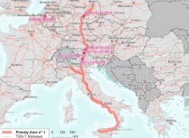
The TEN – corridor priority project No.1 from Berlin (in fact Rostock) to Palermo including more than 2,400 km of new railway lines is, largely, under construction or already operational (Figure 1). The new Brenner Railway Line with the Lower Inn Valley stretch and the Brenner Base Tunnel is a part of this corridor. It should be mentioned that the stretch from Naples to Verona has been operational since December 2009 and that the 42 km long Lower Inn Valley stretch will be activated by the end of 2012 [1]. The Innsbruck bypass was constructed in 1994 and will be a part of the underground stretch of the Brenner Base Tunnel.
The construction of the exploratory tunnel is well underway. The lessons learned here along with the various project optimizations will be integrated into the cross-project system planning (guide design). Thus, a uniform basis for further tendering and executive planning of the Brenner Base Tunnel will be created. Tenders for the Ampass access tunnel and the Wolf access tunnel as well as further sections of the exploratory tunnel through the periadriatic seam between Mauls and Trens are to be requested during 2011. These investigations are accompanied by careful monitoring and numerical simulations to determine water penetration and the time-related geomechanical behaviour.

