Metro Line 4 in Rio de Janeiro
2012 kicks off a 4 year marathon for Rio, beginning with the Rio+20 Summit on the environment, and running the ’14 World Cup and the ’16 Summer Olympics. The following article shows, how tunnelling helps to prepare the infrastructure in Rio de Janeiro.
There is no question this is the most prosperous moment that Rio de Janeiro experiences since the days when still housed significant political decisions as the Brazilian capital. While the government injects reais into the economy and announces new investments in infrastructure and housing, the „carioca” population, name given to those born in the city, grows and develops by the limits of Rio, up today to 11.7 million people.
Still, just as all great world metropolis, the city suffers from severe traffic issues. Due to the necessity of vehicle traffic reduction in roads, and taking advantage of favorable geological conditions, in order to further the preservation of the citie‘s environment that boasts the largest urban forest in the world, projects and plans have been developed to expand its metro network. Nowadays, the subway system of the city has 40.9 km in length split into 2 lines, Line 1 and Line 2. At the outbreak of the current subway plan is the creation of the Metro Line 4 of Rio de Janeiro.
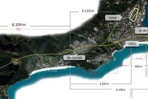
The Line 4, scheduled to start operating in 2016, extends for 16 km through rock masses, canals and ocean regions. The peculiarity of the local geography limits the options for road access to the different neighbourhoods where the line is stretched, thus making the subway access necessity even more essential. Due to the multiplicity of geological features, several engineering works are being held, such as bridges, hillsides retaining walls and tunnels mainly using NATM methodology for rocky stretches and cut and cover and TBM for sandy soils (Fig. 1).
The new line is located at the south and west portion of the city, the second being the region with the largest population growth in the last decade. At the end, it connects to the existing Line 1, which caters primarily to the neighbourhoods located in the center and north of the city. At the year of inauguration are predicted 425,000 passengers daily utilizing the services of Line 4, and nearly 950,000 passengers in the total of the 3 lines, thereby bringing a huge relief for vehicle traffic on major avenues in Rio. Crossings that in times of heavy traffic can last up to 2 hours by car will be shortened to 30 minutes using the metro.
The activities for the implementation of Line 4 began in March 2010 and since then the excavations are being executed one step ahead of 4.5 m per day, yet in rocky areas. There are 5 companies that form the Consortium Builder Rio Barra (CCRB), which now has the participation of 1,600 employees, and forecasts to reach 2,500 employees between production and administration.
For the extension of 9 km stretches out the route that includes the stations of Jardim Oceanico, São Conrado and Gávea. Due to the presence of rock in its entirety, this section is excavated through the drill and blast method. Currently there are 3 digging fronts to obtain advances, 1 at the beginning of the path and 2 at the intermediate portion, located at São Conrado station, where 2 fronts in opposite directions where started. The entire length of the tunnel will be excavated in November 2013, accounting for a total of 41 months of excavations.
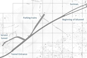
There are several sections of excavation that goes from 33 m² and reaches 368 m² at the São Conrado station which will have its total length of 179 m excavated in solid rock. The slimmer sessions are due to a choice for a project that includes 2 single-track tunnels, known as twin tunnels. Surveys were performed seeking the most viable solution, meeting international standards for security. It was presented as a viable option, the construction of 2 parallel tunnels, whose sectional excavated area is notably the same as a double track tunnel, with the advantage, instead of outputs to the outer surface, the passage through galleries for the tunnel adjacent track. The cross passages between the single tunnels every 244 m fits the bill as one of the safest in the world in this regard. In addition to aggregate solution, the auxiliary facilities required to supply the energy system over the tunnels, was designed in an integrated manner with the interconnections between the tunnels, optimizing the placement and execution of the same tunnels. These solutions allowed the project to follow the NFPA 130, an international standard used in the evacuation of large tunnels in case of operational accident (Fig. 2).
Excavation cycle
During the investigations 152 drillings were performed, including a modern method of televising the layers of holes. The technique is based on achieving color images of the walls of holes, both above and below the water level, which properly processed allows viewing, editing and analyzing the images in a practical way. Through this practice, it was possible to analyze cracks, discontinuities, faults, and other geomorphological features. In addition, seismic surveys were performed (electrical profiling) in areas where its geological complexity and fragility demanded further investigations. After the completion of studies on 2 August 2010 the first blast to advance the excavation was performed. Since then, the improvements of techniques and procedures have been constant, so that productivity and safety are in increasing trend. Currently, the first line of excavation is advancing with almost 2 km. At the end of the initial 682 m excavated as a session of up to 122 m², the tunnel splits into the 2 single tubes of 33 m².
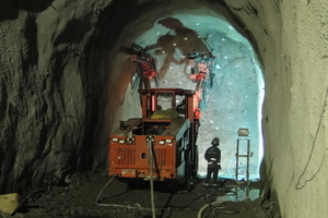
Usually there are 2 daily detonations, and they occur in the interval between the steps of the cycle, that begins with clearance of demolished material and ends up at the explosives loading for detonation. For drilling, the consortium has 7 drilling machines (jumbos) with spears range of 4.5 m. On average 2.5 hours are required for execution of the 71 holes, 13 of them at the center pilot, and the rest is spread over the typical session of 33 m². For detonations, cartridge emulsion, silent lines and fuses are used (Fig. 3).
Through the perforation of 4 m, obtains the average of 3.70 m advance counting thus 124 m³ of disassembled rock which is then transported for disposal in place approved by environmental authorities. Furthermore, the cycle counts with the use of excavators, loaders and lifters that through an efficient and aligned logistics system takes turns at the excavation front seeking lower production downtime. In total, there are 9 excavators, 6 loaders to transport material and 8 lifters which are used for the implementation of shotcrete, placement of rods and other ancillary services such as extensions of networks of utilities and ventilation ducts.
It is during loading and blasting that security becomes even more necessary. In addition to the ventilation system, with jet fans and 1.800 mm diameter duct along each single tunnel, the tunnels also feature signalling, unique passages for pedestrians and safety staff during the 24 hours of services divided into 3 shifts.
Geological fault of Soriman
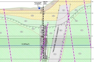
Geomorphological changes are observed and studied each advance. In addition to challenging, it increases the risk of schedule and cost variation. Results of the surveys identified a stretch of the tunnel passage in which a geological discontinuity with the presence of water could affect the pace of excavations. Due to the lack of geomechanics quality, as a function of increased frequency of subvertical joints cutting across the tunnel, and locally filling fractures with solid carbonate or Kaolinite with the presence of water, all necessary measures were taken to ensure safety.
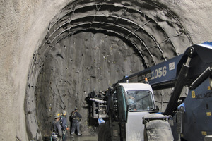
The decision taken for cautious measures includes: advance of 1.5 m per detonation, crankshafts spaced at 0.80 m each, rods placement with 4 to 5 m in length plus steel frames and pre-grouting. To combat the water column of approx. 40 m it was used a 500 mm layer of shotcrete in addition of waterproofing membrane. Despite the decrease in the rate of excavation of approx. 75 %, the dreaded 247 m have been successfully overcome, and in no time “yellow light was lit“ (Fig. 4).
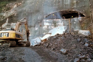
In June 2011, after completion of the service tunnel excavations, began the process of opening the mouth of the tunnel on its starting point in Barra da Tijuca, but as the service tunnel was already completed, this time the direction of the excavations would be inside the tunnel out. Due to the proximity of buildings, which limits the use of explosives to demolitions and also because of its format of a big vertical wall of solid rock with no soil, it was opted for the methodology of cutting with diamond wire.
The process comprises a steel wire with cutting rings (beads or diamonds) separated by regularly spaced segments of special plastics or springs. These wires are driven machines that makes arthritis with the rock at the same time is pulled towards the desired cut, producing the cut. The movement of the wire is made by the pulleys, and the traction is made by the machine translation on rails. After slicing the total rectangle arc section with 15.30 m wide and 7.88 m high, it was necessary to use a hydraulic breaker to open the section and further transportation of excavated material (Fig. 5).
São Conrado excavations
Following the excavation of the Tunnel, began excavations at the second service tunnel, located on the rocky hillside of São Conrado, with the sectional area of approx. 90.80 m², from which followed the excavations for the underground station of the same name and also enabled the creation of 2 new digging fronts in opposite directions.
At the mouth of the service tunnel it was completed the first stage of treatments and it was also built a fake tunnel with 27 metal crankshafts in addition to shotcrete. The geological investigations that were held at the location indicated an initial stretch with only 3 m in length, to be dug in soil and saprolite rock alteration, entering below the crystalline rock mass on the horizon dominated by facoidal gneiss that occurs in the massive rock formations near the coastal region of Rio de Janeiro.
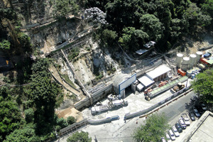
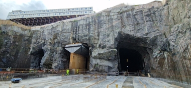
These initial excavations were carried out mechanically, followed by rock excavation developed by applying techniques called “cold disassemble”, with hydraulic breakers and also small flares with explosives, that are required to conform and upright the front of rock excavation itself (Fig. 6).
After excavation of approx. 10 m, gate of steel and concrete was installed, completely closing the mouth of the new tunnel to be excavated. Its function would then be to attenuate noise in addition to protection due to the positioning of the detonations, nearby a street with large movement of people and vehicles, and its forward position to inhabited buildings, offices and commerce in general.
These auxiliary structures, allowed the start and continuation of the excavations, with the systematic use of explosives, but with more rigorous safety procedures, diverse instrumentation of tunnel and hillside, and more accurate fire plans.
The rock mass on the slope where the tunnel is being excavated features geological and geomechanical adverse conditions in their upper bounds. At some points, instability situations are revealed, evidenced by torrential rains that occurred in April 2010, before the start of work on implementation of Line 4. During this event there was slippage of part of the colluvial layer deposited on the rocky mass. Although no casualties have been originated, the event caused several damages to the region, including the destruction of homes and obstruction of public roads.
Given the presented scenario, an extensive project of contention was prepared for the hilly area, including several types of rods, coatings with shotcrete, and the construction of containing walls. So far 736 root piles have been implemented, divided into 17 retaining walls along the hillside. Thus, the geographical position, the geomechanical and geological conditions of the São Conrado site area caused mandatory practices of security procedures for the excavation with explosives.
The “Favela” Rocinha
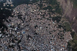
It is well known in the community of tunnels, that underground construction in urban environments poses eminent risks to buildings and avenues during its excavation. This risk is even more enhanced in the case of the construction of Metro Line 4 of the Rio de Janeiro. Along its route, the tunnel crosses beneath one of the leading and oldest slums of Rio de Janeiro (Fig. 7).
Rocinha, as is renowned, currently has a population of approx. 70,000 inhabitants over an area of 1.43 km². Located at a large area of hillside and valleys, had its occupation process started in 1940 by people who believed to be public those lands, i.e. without owner.
From the 1950s, there was a migration rise of people from the Brazilian Northeast to Rio de Janeiro in pursuit of employment and better living standards by directing in part to Rocinha. During the 1960s and 1970s, there was a new surge of population, now because of projects to opening of Reboucas and Two Brothers tunnels, which contributed to a greater availability of employment in the region. Nowadays these inlined highway tunnels are part of the main access route to the west side suburbs.
The constant migration movements into Rocinha, have made it massively populated, a fact which resulted in several problems for the region. Due to the uncontrolled occupation and the lack of an urban plan, the buildings in the area have serious structural problems. Buildings of up to 8 floors were built, away from supervision and approval of the responsible agencies. The space is constantly changing due to the action of the residents who builds homes without first consulting technical experts, offering an imminent risk for the entire community.
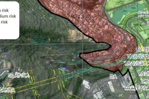
In order to establish a close communication with the community, the Consortium provides several channels of contact. Preliminary inspection on the buildings, registrations, meetings and periodic visits and communications reporting on the execution of services are continuously being made. Furthermore, benefactors were carried out such as the revitalization of parks and the reform of the Rocinha’s residents association. These actions have promoted the harmonization with the communities where the work is located, facilitating the implementation of services. As a consequence of heavy rains in mid-2010 landslides occurred in the region of Rocinha, a warning was generated for the risk and the possibility of disasters within the region. Under this scenario, studies have been conducted through the Geotechnics Institute of Rio de Janeiro - GEO-Rio, involving drilling, topography and structural analysis of buildings that led a mapping of local risk (Fig. 8).
By these studies it was identified a critical area through which the tunnel is being dug, which generated several actions that involves from the concern for the welfare of the community up to procedures for the fire plan. The passage at issue, of approx. 200 m, features difficulties because it is a region where the coverage over the tunnel is very thick in some locations reaching 15 m of colluvium soil, and 8 m of rock highly fractured, altered and not very coherent, evidenced through survey testimonials recovery. Adds up to this fact, the constant contamination of the ground in the slum area, mostly due to lack of sewage system, which contributes straight to the physical and chemical alteration of soil and rocks, causing loss of quality (Fig. 9).
Given the challenges, many procedures are being adopted. As an example, the instrumentation of the region with the participation of a team which monitors the area through repression pins, tassometers, piezometers and seismometers that are used at the moment of the detonations. 50 homes located in areas of influence of the works are receiving repression pins and are being daily monitored. The analysis considers horizontal and vertical displacements of the pins and are provided in real-time for the designers, so they can carry out specific modifications in advance of excavation activities.
In order to assess the vibrations triggered by blasting, seismographs with geophones are being used. Prior to each blast 4 reading points are maintained on the nearest residential buildings, usually fixed to the pillars. Such locations refer to points on the surface which are located closest the front of the excavation. For the present stage, it was determined that it should limit the velocity of vibration that can hit the inhabited areas of Rocinha and risky sliding areas by 4.2 mm/s in the resulting. If this value is exceeded for 3 consecutive captures to a maximum of 6 mm/s, or if a single abstraction exceeds 6 mm/s, it will be necessary to act following the excavation sequence, advance and fire plan to return to the safety limit above. The value of 128 dBl must be adopted as a limit of air impact. This measure seeks to reduce the physical and psychological effects of blasting on the community, knowing that such limits exempt impacts to the environment and living creature. However, up to now, displacements or vibrations exceeding the limits set out have not been captured as a function of high safety and conservatives actions.
São Conrado fire plan
Currently, the advance of the tunnel in São Conrado is in the vicinity of where the risks related to the surface shows the highest. The blasting for advancement in a 184 m² section partialized in upper and lower part (bench). There are several reasons for choosing this methodology, among then there is the lowest use of explosives by detonation due to the necessity of noise and vibration mitigation and the limitation of the perforation machines (jumbos).
The partialization of advancement of the section is performed so that the advance at the top of the tunnel face is always ahead of the lower section of the bench. Furthermore, the bench is divided into right and left, each with 40 m². According to the designers, the sides of the bench must be detonated in different cycles and must constantly be at least 8 m apart. This definition accords to the requirement to protect the sides of the tunnel section, once the complete detonation section would lead to vulnerability to collapse the tunnel walls. Therefore, when performing the detonation of a side there is the possibility to perform there, the necessary treatment for protection and accommodation of the mass thus releasing the advance opposite portion. Furthermore, the following detonation of a lower part side, allows the assembly of a ramp of the material itself on the opposite flank disassembled, thus allowing access to the execution of services on the upper level, which is already advanced.
The partialization of the tunnel section occurs in 3 stages, at the first step, the face of the dome suffers the drilling of 228 uniform holes. The dismantling of the shell volume of approx. 421 m³ requires the amount of 950 kg of explosive, resulting in a charge ratio of 2.25 kg/m³. The detonation of the center pilot area, equivalent to approx. 1.20 m2, where the highest concentration of loading blast occurs milliseconds before the rest, providing relief of tension that facilitates the targeting sequence of rock takedowns. Each of the 46 holes that defines the contour of the section receives a loading of a cartridge emulsion of 0.532 kg of ammonium nitrate and another of the same weight in the middle. To smooth the cutting edge, avoiding over breaks, it is applied a NP40 line (40 g/m NH4NO3) along the depth of the hole. This method was chosen over the method commonly called “barbecue”, which was initially used and consists in the insertion in the hole of a bamboo cut lengthwise and loaded with less effective cartridge emulsions. However, this method generates more irregular cuts, sometimes causing rework and inaccurate rock cuttings.
For detonation of the bench, fewer explosives are used, since the free face above the area to be advanced is no longer confined, requiring only what it is the “rising fire”. Overall, advances in the bench area are more agile than the upper part, due to the reduced size of section and less need for treatment. For each detonation of the cap feed is 3.60 m, obtaining 90 % efficiency relative to of the drill perforation. It was determined that if there are mentioned problems related to excessive vibrations in the regions bordering the excavation front, the fire plan will be modified so that the area of the cap, which has the largest load is reduced, thus increasing the area of the lower part. For not being confined, the detonation of the lower portion generates less vibration reaching the surface. These adjustments were not needed yet, since the captures of the seismographs are still far below the stipulated limits.
Conclusion
The construction of Metro Line 4 that connects West and South Zone is in fact an essential work running in the city of Rio de Janeiro, not only because of its importance to the improvement of mass transportation for the 2016 Olympics, but also for what represents as a legacy to the urban planning of the city. During its development the work causes interventions in traffic and the daily routine of the population, which becomes conscious in favour of the improvements for the city itself. On the other hand, the building Consortium, seeks to mitigate the impacts of work in Rio by generating a series of environmental actions that add value to the city. Among these actions are the transplantation of a bromeliad area, recovery of public facilities, in addition to the recycling of 120 t of metal, 9 t of paper and reuse of 50 million l of water used for the services.
For the completion of the work there are still remains 4 years ahead, and up to there many challenges will be faced. Also planned there are the construction of a bridge, excavation of stations in soil and rock and other services that require the best engineering practices. But the progress of work has shown that the staff has been performing its role with commitment and perseverance so the work can be completed by 2016 and this important gift delivered to the population of the city‘s owner to the world‘s most enchanting beauty.

